
파일:Korea Broadcasting System (KBS) 한국방송공사 (5481447848).jpg
원본 파일 (983 × 541 픽셀, 파일 크기: 213 KB, MIME 종류: image/jpeg)
_%ED%95%9C%EA%B5%AD%EB%B0%A9%EC%86%A1%EA%B3%B5%EC%82%AC_(5481447848).jpg?uselang=ko)
파일 설명
| 설명 |
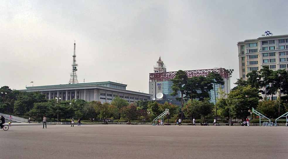
English: These buildings mark the headquarters of South Korea's government-run broadcaster, Korea Broadcasting System, usually abbreviated and referred to as KBS.
As a public broadcaster, KBS has the right to collect license fees on every television set in the nation, an arrangement also used by the BBC and many other national public broadcasters. KBS also runs international broadcasting service KBS World, which can be received via a number of channels (World Radio Network for the radio service, for example - and in North America, SiriusXM carries World Radio Network); again, KBS World is similar to other countries' national broadcasters' English-language international services. The glassy middle building is the International Broadcast Center, which was built to allow foreign media crew to broadcast coverage of the 1988 Summer Olympic Games here in Seoul, to their home countries. It still displays the symbol of the 1988 Games. KBS-produced soap operas and dramas are a key component of the so-called Korean Wave that has taken Asia, and parts of the world beyond, by storm. |
| 날짜 | 촬영 날짜: 2008년 10월 4일, 14:49 |
| 출처 | |
| 저자 |
English: InSapphoWeTrust from Los Angeles, California, USA |
| 카메라 위치 | | 이 지역의 다른 사진을 보기: OpenStreetMap |
|---|
_%ED%95%9C%EA%B5%AD%EB%B0%A9%EC%86%A1%EA%B3%B5%EC%82%AC_(5481447848).jpg¶ms=037.525928_N_0126.922302_E_globe:Earth_type:camera_source:Flickr_&language=ko)
라이선스
- 이용자는 다음의 권리를 갖습니다:
- 공유 및 이용 – 저작물의 복제, 배포, 전시, 공연 및 공중송신
- 재창작 – 저작물의 개작, 수정, 2차적저작물 창작
- 다음과 같은 조건을 따라야 합니다:
- 저작자표시 – 적절한 저작자 표시를 제공하고, 라이센스에 대한 링크를 제공하고, 변경사항이 있는지를 표시해야 합니다. 당신은 합리적인 방식으로 표시할 수 있지만, 어떤 방식으로든 사용권 허가자가 당신 또는 당신의 사용을 지지하는 방식으로 표시할 수 없습니다.
- 동일조건변경허락 – 만약 당신이 이 저작물을 리믹스 또는 변형하거나 이 저작물을 기반으로 제작하는 경우, 당신은 당신의 기여물을 원저작물과 동일하거나 호환 가능한 라이선스에 따라 배포하여야 합니다.
| 플리커에 게시된 이 그림은 2013년 1월 27일에 관리자 혹은 신뢰된 사용자 File Upload Bot (Magnus Manske)에 의해 검토되어, 이 날짜를 기준으로 위의 라이선스로 사용 가능함이 확인되었습니다. |
파일 역사
날짜/시간 링크를 클릭하면 해당 시간의 파일을 볼 수 있습니다.
| 날짜/시간 | 섬네일 | 크기 | 사용자 | 설명 | |
|---|---|---|---|---|---|
| 현재 | 2015년 6월 6일 (토) 19:51 | | 983 × 541 (213 KB) | Kimsaka | Total makeover... |
| 2013년 1월 28일 (월) 01:48 |  | 1,000 × 750 (187 KB) | File Upload Bot (Magnus Manske) | Transferred from Flickr by User:russavia |
이 파일을 사용하는 문서
이 파일을 사용하고 있는 모든 위키의 문서 목록
다음 위키에서 이 파일을 사용하고 있습니다:
- bg.wikipedia.org에서 이 파일을 사용하고 있는 문서 목록
- de.wikipedia.org에서 이 파일을 사용하고 있는 문서 목록
- el.wikipedia.org에서 이 파일을 사용하고 있는 문서 목록
- en.wikipedia.org에서 이 파일을 사용하고 있는 문서 목록
- fi.wikipedia.org에서 이 파일을 사용하고 있는 문서 목록
- fr.wikipedia.org에서 이 파일을 사용하고 있는 문서 목록
- hu.wikipedia.org에서 이 파일을 사용하고 있는 문서 목록
- id.wikipedia.org에서 이 파일을 사용하고 있는 문서 목록
- ja.wikipedia.org에서 이 파일을 사용하고 있는 문서 목록
- ko.wikipedia.org에서 이 파일을 사용하고 있는 문서 목록
- ku.wikipedia.org에서 이 파일을 사용하고 있는 문서 목록
- nl.wikipedia.org에서 이 파일을 사용하고 있는 문서 목록
- no.wikipedia.org에서 이 파일을 사용하고 있는 문서 목록
- pl.wikipedia.org에서 이 파일을 사용하고 있는 문서 목록
- pt.wikipedia.org에서 이 파일을 사용하고 있는 문서 목록
- sk.wikipedia.org에서 이 파일을 사용하고 있는 문서 목록
- sv.wikipedia.org에서 이 파일을 사용하고 있는 문서 목록
- tl.wikipedia.org에서 이 파일을 사용하고 있는 문서 목록
- tr.wikipedia.org에서 이 파일을 사용하고 있는 문서 목록
- uk.wikipedia.org에서 이 파일을 사용하고 있는 문서 목록
- vi.wikipedia.org에서 이 파일을 사용하고 있는 문서 목록
- zh-classical.wikipedia.org에서 이 파일을 사용하고 있는 문서 목록
- zh.wikipedia.org에서 이 파일을 사용하고 있는 문서 목록
_한국방송공사_(5481447848).jpg)